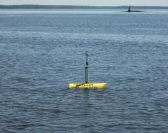
LOBO-0025 Penobscot River
Penobscot Bay, situated in the mid coast region of Maine, originates at the mouth of the Penobscot River. The Penobscot River, Maine, is the second largest river in New England, draining a 20,109 km² watershed which is forested with extensive bogs, marshes and wooded swamps and is sparsely populated. Land-use activities range from unregulated municipal and industrial disposal, to logging and agriculture. Average daily discharge is ~382,000 m³/day, peaking in March-April with a second peak in November-December.
As a part of research project investigating the land to ocean transport of carbon, a LOBO system was installed in the upper Penobscot Bay to monitor surface water quality. Research scientists from WET Labs (Dr. Andrew Barnard) the University of Maine, School of Marine Sciences (Dr. Collin Roesler) are using the data provided by the LOBO to understand the fate of particulate and dissolved materials originating from the terrestrial environment as they are transported through the Penobscot River the marine environment. Support for this research has been provided by the Office of Naval Research.
The LOBO was deployed on June 22, 2008 using the RV Argo (Downeast Marine Resources, Inc) ~2.5 nautical miles downstream of the Penobscot Narrows Bridge (click here to view a live web cam image of the bridge) near Bucksport, ME. The sampling interval for the LOBO measurements is every two hours. Data is delivered to the LOBOviz web site through cellular phone communications. Note that periodic latencies in the data delivery are to be expected due to intermittent cellular phone coverage in the region.
Configuration
44°31.183N 68°48.120W
Archived Data
Use LOBOviz to graph and download archived data from this LOBO node.
Other LOBO Systems
See other LOBO systems in action:
- SCCF RECON, Florida
- Northwest Arm, Nova Scotia
- Columbia River, Oregon
- Yaquina Bay, Oregon
- Elkhorn Slough, California


